
Australian climate projections estimate how Australia’s climate is likely to change under different assumptions about future greenhouse gas emissions. Federal and state governments rely on them to plan infrastructure, manage water and agriculture, and prepare for and adapt to climate extremes. But what are these projections based on?
Trace any projection back far enough and you reach the same starting point: a set of global climate models that includes the Australian Community Climate and Earth System Simulator (ACCESS), Australia’s own climate model.
A new infographic, “Where did my climate projections come from?”, released by the National Environmental Science Program (NESP) and National Partnership for Climate Projections (NPCP) shows how climate models and climate projections in Australia are connected.
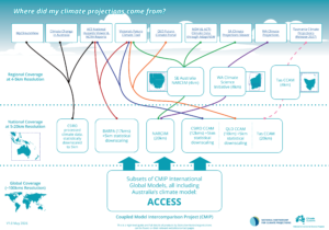 At the base of the infographic are global climate models: computer simulations of the whole planet’s atmosphere, oceans, land, ice and biological systems. Modelling centres around the world run the same set of experiments through the Coupled Model Intercomparison Project (CMIP), so their results can be compared and combined. CMIP results also underpin the reports of the Intergovernmental Panel on Climate Change (IPCC).
The levels in the infographic show how these global results are downscaled. A global model gives a low-resolution picture of the future climate: you can see the big picture, but not the detail. Downscaling translates that picture into what it means for your region, taking local hills, coasts and valleys into account. The information is then delivered in stakeholder focused data platforms tailored for different needs.
Australia contributed two versions of ACCESS to the sixth phase of CMIP (CMIP6): ACCESS-CM2 and ACCESS-ESM1.5. Every downscaled dataset on the infographic includes at least one of these ACCESS models. Australia’s participation in CMIP through ACCESS is therefore the foundation of the projections that governments, industry and communities use to plan.
The seventh phase, CMIP7, is now under way. Over the past three years, the Australian research community and the infrastructure that supports it (ACCESS-NRI and NCI) have been working hard to prepare two improved models, ACCESS-ESM1.6 and ACCESS-ESM3, for submission to CMIP7.
Because Australia builds its own model and takes part in CMIP, decisions about our future are based on science designed for Australian conditions. Without that participation, the national and state projections would rely on models built elsewhere, which often overlook local influences such as the Southern Ocean’s role in future climate and carbon uptake, or Australia’s vegetation unique adaptations to nutrient-poor soil.
Participation also ensures Australian science informs global climate policy and brings a vital Southern Hemisphere perspective, as ACCESS is the leading climate model developed in the Southern Hemisphere.
The original infographic can be found at the Climate Systems Hub website, NESP: https://nesp2climate.com.au/resource/climate-projections-infographic/